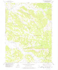
1977 Map of Squaw Valley Peak
USGS Topo · Published 1978About this map
Plumas National Forest serves as the backdrop for this late 1970s survey, where high ridges and steep canyons dictate the layout of seasonal mountain operations. The presence of Stone Dairy Cabin, Jenkins Sheep Camp, and Ridenour Barn points to a landscape historically utilized for livestock grazing and summer range management. These scattered structures are linked by an Old Railroad Grade and various jeep trails, reflecting the legacy of early timber extraction or mountain transport in the region near Squaw Valley Peak. In the southern portion of the sheet, the State Game Refuge 1-P and the drainages of Squaw Queen Creek define a protected wilderness character. The transition from industrial infrastructure like Camp 13 to conservation areas illustrates the shifting priorities of the Plumas County highlands during this era.
Find a feature on this map
22 named features on this map. Tap any name to fly to it.
Don’t see what you’re looking for? This feature index may not catch every label — zoom into the map to look around manually.
Map Details
Editions of this 1977 Squaw Valley Peak Map
This is the sole edition of this map. No revisions or reprints were ever made.
Other maps of this area

1886 · Honey Lake
USGS Topo · 1:250,000

1890 · Sierraville
USGS Topo · 1:125,000

1891 · Downieville
USGS Topo · 1:125,000

1891 · Honey Lake
USGS Topo · 1:250,000

1892 · Sierraville
USGS Topo · 1:125,000

1893 · Honey Lake
USGS Topo · 1:250,000

1893 · Downieville
USGS Topo · 1:125,000

1894 · Sierraville
USGS Topo · 1:125,000

1895 · Downieville
USGS Topo · 1:125,000

1896 · Downieville
USGS Topo · 1:125,000