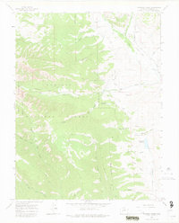
1965 Map of Squirrel Creek
USGS Topo · Published 1975About this map
Gunnison National Forest and the West Elk Wilderness dominate this high-country landscape, revealing a complex network of water management and extraction infrastructure from the mid-1960s. The eastern portion of the sheet is defined by the valley of Ohio Creek, where an Old Railroad Grade follows the water, marking the path of former narrow-gauge routes that once served the region's mining interests. Small-scale operations such as the Smith Mine and Hinkle Mine are visible, while numerous irrigation projects like the Eilebrecht Ditch No 1, Stratman Ditch, and Little Mill Ditch illustrate the diversion of mountain runoff to support valley agriculture. Named peaks like The Pie stand above a series of deep drainages including Mill Creek and Cunningham Creek, connected by the Lowline Trail and Mill Castle Trail.
Find a feature on this map
39 named features on this map. Tap any name to fly to it.
Don’t see what you’re looking for? This feature index may not catch every label — zoom into the map to look around manually.
Map Details
Editions of this 1965 Squirrel Creek Map
4 editions found
Other maps of this area

1888 · Crested Butte
USGS Topo · 1:62,500

1888 · Anthracite
USGS Topo · 1:62,500

1889 · Crested Butte
USGS Topo · 1:62,500

1889 · Anthracite
USGS Topo · 1:62,500

1893 · Anthracite
USGS Topo · 1:62,500

1893 · Crested Butte
USGS Topo · 1:62,500

1894 · Anthracite
USGS Topo · 1:62,500

1954 · Mc Intosh Mountain
USGS Topo · 1:24,000

1954 · West Elk Peak SW
USGS Topo · 1:24,000

1954 · Gunnison
USGS Topo · 1:24,000