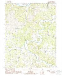
1987 Map of St. Anthony
USGS Topo · Published 1988About this map
Osage River flows through the northern reaches of this Miller County landscape, where the small settlement of Capps sits near the riverbanks. The terrain is defined by a dense network of drainage systems, including Tavern Creek, Brushy Fork, and Barren Fork, which carve through the countryside and create numerous sand areas along their banks. In the south, the village of St Anthony serves as a primary local hub, surrounded by several rural cemeteries that provide significant value for genealogists tracing early families in the Richwoods and Jim Henry townships.
Find a feature on this map
27 named features on this map. Tap any name to fly to it.
Don’t see what you’re looking for? This feature index may not catch every label — zoom into the map to look around manually.
Map Details
Editions of this 1987 St. Anthony Map
This is the sole edition of this map. No revisions or reprints were ever made.
Other maps of this area

1888 · Tuscumbia
USGS Topo · 1:125,000

1894 · Tuscumbia
USGS Topo · 1:125,000

1933 · Iberia
USGS Topo · 1:62,500

1937 · Iberia
USGS Topo · 1:62,500

1947 · Jefferson City
USGS Topo · 1:250,000

1948 · Meta
USGS Topo · 1:62,500
1948 · Eugene
USGS Topo · 1:62,500

1948 · Tavern
USGS Topo · 1:62,500
1950 · Meta
USGS Topo · 1:62,500
1950 · Tavern
USGS Topo · 1:62,500