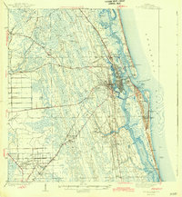
1943 Map of St. Augustine
USGS Topo · Published 1943About this map
St Augustine and its historic coastal environs are captured here just before the mid-century building boom, dominated by the intricate waterways of the Matanzas River and Tolomato River. The map details a landscape transitioning from the ancient town core at Fort Marion Nat Mon and the Fountain of Youth to the sprawling wetlands of Ninemile Swamp and Sixmile Swamp to the west. Evidence of the region’s educational and religious foundations is visible through sites like the State Normal Institute and St Ambrose Sch. Transport patterns are defined by the Florida East Coast railway and historic corridors like the Old Dixie Highway and Kings Road. The presence of numerous family-named islands such as Masters Island and Simone Island amidst the marshes suggests a long history of local land use and seasonal navigation before modern drainage and development altered the Floridian interior.
Find a feature on this map
76 named features on this map. Tap any name to fly to it.
Don’t see what you’re looking for? This feature index may not catch every label — zoom into the map to look around manually.
Map Details
Editions of this 1943 St. Augustine Map
2 editions found

Other maps of this area

1912 · Palatka
USGS Topo · 1:48,000

1915 · Palatka
USGS Topo · 1:62,500

1917 · Orange Park
USGS Topo · 1:62,500

1918 · Orange Park
USGS Topo · 1:62,500

1918 · Palm Valley
USGS Topo · 1:62,500

1927 · Matanzas
USGS Topo · 1:48,000

1937 · Bakersville
USGS Topo · 1:24,000

1937 · Elkton
USGS Topo · 1:24,000

1937 · Crescent Beach
USGS Topo · 1:24,000

1937 · Dinner Island
USGS Topo · 1:48,000
Featured Places
- Saint Augustine, FL
- Saint Augustine Beach, FL
- Saint Augustine South, FL
- Saint Augustine Shores, FL
- Butler Beach, FL