
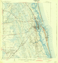
1943 Map of St. Augustine
USGS Topo · Published 1943About this map
St Augustine serves as the focal point of this 1943 survey, showing the ancient city before the heavy coastal development of the late 20th century. Historic landmarks like Fort Marion Nat Mon, the Lighthouse Reservation, and the Fountain of Youth stand prominently along the Matanzas River. The landscape reveals a complex network of waterways, including the Florida Intracoastal Waterway and Tolomato River, which shaped the city's maritime identity.
Find a feature on this map
83 named features on this map. Tap any name to fly to it.
Don’t see what you’re looking for? This feature index may not catch every label — zoom into the map to look around manually.
Map Details
Editions of this 1943 St. Augustine Map
2 editions found
Other maps of this area

1912 · Palatka
USGS Topo · 1:48,000

1915 · Palatka
USGS Topo · 1:62,500

1917 · Orange Park
USGS Topo · 1:62,500

1918 · Orange Park
USGS Topo · 1:62,500

1918 · Palm Valley
USGS Topo · 1:62,500

1927 · Matanzas
USGS Topo · 1:48,000

1937 · Bakersville
USGS Topo · 1:24,000

1937 · Elkton
USGS Topo · 1:24,000

1937 · Crescent Beach
USGS Topo · 1:24,000

1937 · Dinner Island
USGS Topo · 1:48,000
Featured Places
- Saint Augustine, FL
- Saint Augustine Beach, FL
- Saint Augustine South, FL
- Saint Augustine Shores, FL
- Butler Beach, FL