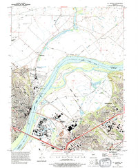
1994 Map of St. Charles
USGS Topo · Published 1995About this map
St Charles serves as the focal point of this mid-1990s survey, situated along the western bank of the Missouri River opposite the large landmass of Bryan Island. The city's educational and religious foundations are clearly visible, featuring landmarks like Lindenwood College, Duchesne High Sch, and Emmaus Cem. The map illustrates a complex landscape of river management and industrial expansion, with a network of levees and roads on levees protecting the bottomlands. To the southeast, the urban footprint of Bridgeton and Hazelwood expands toward Natural Bridge Junction, while the development of Earth City and Champ indicates the era's significant commercial and infrastructure growth. Recreational spaces such as Kister Park and the Katy Trail follow the riverfront, contrasting with the logistical sites like St Charles Airport and several large sewage disposal ponds.
Find a feature on this map
73 named features on this map. Tap any name to fly to it.
Don’t see what you’re looking for? This feature index may not catch every label — zoom into the map to look around manually.
Map Details
Editions of this 1994 St. Charles Map
This is the sole edition of this map. No revisions or reprints were ever made.
Other maps of this area

1903 · O'Fallon
USGS Topo · 1:125,000

1924 · Robertson
USGS Topo · 1:24,000

1927 · St. Charles
USGS Topo · 1:62,500

1931 · Brussels
USGS Topo · 1:62,500

1932 · Manchester NE
USGS Topo · 1:24,000

1933 · Creve Coeur
USGS Topo · 1:24,000

1933 · Clayton
USGS Topo · 1:24,000

1933 · Saint Charles
USGS Topo · 1:62,500

1935 · Florissant
USGS Topo · 1:24,000

1939 · Brussels
USGS Topo · 1:62,500