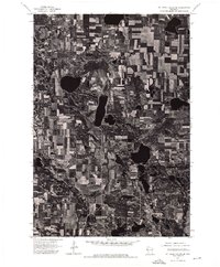
1974 Map of St. Croix Dalles SE
USGS Topo · Published 1976About this map
The Apple River snakes through this agricultural landscape in Polk County, revealing a complex network of glacial landforms and field patterns as they appeared in the mid-1970s. This orthophotoquad is built from an aerial photograph taken on October 12, 1974, providing a direct visual record of land use and vegetation during the autumn season. The high-contrast imagery highlights the numerous kettle lakes and wetland depressions characteristic of this region, alongside a dense patchwork of rectangular farm fields. Small woodlots and forested corridors remain primarily along the steeper banks of the Apple River and around the perimeter of the larger water bodies, showing the balance between natural drainage systems and intensive dairy or crop farming in this part of Wisconsin.
Find a feature on this map
1 named feature on this map. Tap any name to fly to it.
Don’t see what you’re looking for? This feature index may not catch every label — zoom into the map to look around manually.
Map Details
Editions of this 1974 St. Croix Dalles SE Map
This is the sole edition of this map. No revisions or reprints were ever made.
Other maps of this area

1900 · St Croix Dalles
USGS Topo · 1:62,500

1901 · St Croix Dalles
USGS Topo · 1:62,500

1948 · New Richmond
USGS Topo · 1:62,500

1949 · New Richmond
USGS Topo · 1:62,500

1950 · Deer Park
USGS Topo · 1:62,500

1950 · Balsam Lake
USGS Topo · 1:62,500

1953 · Stillwater
USGS Topo · 1:250,000

1955 · St. Croix Dalles
USGS Topo · 1:62,500

1955 · Stillwater
USGS Topo · 1:250,000

1958 · Stillwater
USGS Topo · 1:250,000