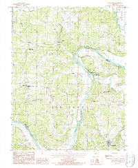
1987 Map of St. Elizabeth
USGS Topo · Published 1988About this map
The Osage River dominates this mid-1980s landscape, carving a deep, meandering path through the hills of central Missouri. This reach of the river is defined by sharp bends and unique geological formations, including a Natural Bridge and several cavern systems such as Klugs Cave and Bat Cave. The river serves as a natural boundary between Clark, Jim Henry, and Osage townships. Small rural settlements like St Elizabeth and Marys Home anchor the uplands, while the Osage-Tavern State Wildlife Area occupies the bottomlands at the confluence with Tavern Creek. A network of wooden pole trans lines and unimproved roads reveals the transition from river-bottom utility to high-ground farming and timber. The map also records the presence of Jones Island and numerous springs and creeks, including Little Tavern Creek and Whalen Creek, which drain the varied topography into the main Osage channel.
Find a feature on this map
29 named features on this map. Tap any name to fly to it.
Don’t see what you’re looking for? This feature index may not catch every label — zoom into the map to look around manually.
Map Details
Editions of this 1987 St. Elizabeth Map
This is the sole edition of this map. No revisions or reprints were ever made.
Other maps of this area

1888 · Tuscumbia
USGS Topo · 1:125,000

1894 · Tuscumbia
USGS Topo · 1:125,000

1933 · Iberia
USGS Topo · 1:62,500

1937 · Iberia
USGS Topo · 1:62,500

1947 · Jefferson City
USGS Topo · 1:250,000

1948 · Meta
USGS Topo · 1:62,500
1948 · Eugene
USGS Topo · 1:62,500

1948 · Tavern
USGS Topo · 1:62,500
1950 · Meta
USGS Topo · 1:62,500
1950 · Tavern
USGS Topo · 1:62,500