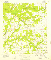
1957 Map of St. Elmo
USGS Topo · Published 1958About this map
St Elmo and the surrounding coastal plain of southern Alabama appear here in the mid-1950s, characterized by a network of rural churches and agricultural homesteads. The L & N RR cuts diagonally through the landscape, anchoring the settlement of St Elmo near the St Elmo Landing Field. This era shows a community structured around local institutions like the Dawes-Union Sch and several houses of worship, including Providence Ch, Union Church, and St Johns Ch.
Find a feature on this map
27 named features on this map. Tap any name to fly to it.
Don’t see what you’re looking for? This feature index may not catch every label — zoom into the map to look around manually.
Map Details
Editions of this 1957 St. Elmo Map
4 editions found
Other maps of this area

1921 · Grand Bay
USGS Topo · 1:62,500

1921 · Delchamps
USGS Topo · 1:62,500

1922 · Mobile
USGS Topo · 1:62,500

1940 · Mobile
USGS Topo · 1:62,500

1941 · Cedar Point
USGS Topo · 1:62,500

1941 · Hurley
USGS Topo · 1:62,500

1942 · Theodore
USGS Topo · 1:31,680

1943 · Cedar Point
USGS Topo · 1:62,500

1943 · Theodore
USGS Topo · 1:31,680

1943 · Grand Bay
USGS Topo · 1:62,500