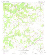
1957 Map of St. Elmo
USGS Topo · Published 1975About this map
St Elmo serves as a primary rail and transit hub in this mid-century view of southern Mobile County, situated along the L & N RR and Old Pascagoula Road. The landscape is defined by the interlacing waters of Miller Creek, Turkey Creek, and Baker Creek, which carve through the terrain toward the marshy lowlands near Copeland Island. Settlement is clustered around rural community centers like Dawes and Union Church, where the Dawes-Union Sch and local congregations such as Providence Ch and St Johns Ch formed the backbone of local life.
Find a feature on this map
26 named features on this map. Tap any name to fly to it.
Don’t see what you’re looking for? This feature index may not catch every label — zoom into the map to look around manually.
Map Details
Editions of this 1957 St. Elmo Map
4 editions found
Other maps of this area

1921 · Grand Bay
USGS Topo · 1:62,500

1921 · Delchamps
USGS Topo · 1:62,500

1922 · Mobile
USGS Topo · 1:62,500

1940 · Mobile
USGS Topo · 1:62,500

1941 · Cedar Point
USGS Topo · 1:62,500

1941 · Hurley
USGS Topo · 1:62,500

1942 · Theodore
USGS Topo · 1:31,680

1943 · Cedar Point
USGS Topo · 1:62,500

1943 · Theodore
USGS Topo · 1:31,680

1943 · Grand Bay
USGS Topo · 1:62,500