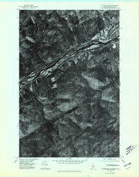
1975 Map of St Francis NE
USGS Topo · Published 1981About this map
The St John River forms a wide, braided international boundary on this 1975 orthophotoquad, separating the northern woods of Maine from New Brunswick, Canada. Along the southern bank, the settlement of St John sits within a corridor of cleared agricultural land that follows the river’s course, contrasting sharply with the dense, textured forest of the interior. This aerial perspective, captured in early October, provides a clear view of the land-use patterns in Aroostook County, where development remains tightly clustered near the water. Away from the border, the terrain transitions into a more remote landscape defined by isolated water bodies like Hunnewell Lake and Bran Lake. The map serves as a precise record of the Canada United States border before modern forest management and subsequent development altered the woodland canopy and settlement footprint.
Find a feature on this map
6 named features on this map. Tap any name to fly to it.
Don’t see what you’re looking for? This feature index may not catch every label — zoom into the map to look around manually.
Map Details
Editions of this 1975 St Francis NE Map
This is the sole edition of this map. No revisions or reprints were ever made.
Other maps of this area

1928 · Eagle Lake
USGS Topo · 1:48,000

1930 · St Francis
USGS Topo · 1:48,000

1931 · Eagle Lake
USGS Topo · 1:62,500

1932 · Fort Kent
USGS Topo · 1:48,000

1933 · St Francis
USGS Topo · 1:62,500

1935 · Fort Kent
USGS Topo · 1:62,500

1962 · Edmundston
USGS Topo · 1:250,000
1975 · St Francis SW
USGS Topo · 1:24,000
1975 · St Francis NW
USGS Topo · 1:24,000
1975 · St Francis SE
USGS Topo · 1:24,000