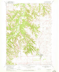
1969 Map of St. Francis
USGS Topo · Published 1972About this map
St Francis serves as the focal point of this late 1960s study, situated within the Rosebud Indian Reservation. The settlement pattern is anchored by the Mission Sch and the Immaculate Conception Ch, reflecting the community's established social and educational infrastructure. The landscape is defined by the sharp transition from the uplands of Grass Mountain down into the deeply incised valleys of the Little White River.
Find a feature on this map
11 named features on this map. Tap any name to fly to it.
Don’t see what you’re looking for? This feature index may not catch every label — zoom into the map to look around manually.
Map Details
Editions of this 1969 St. Francis Map
This is the sole edition of this map. No revisions or reprints were ever made.
Other maps of this area

1955 · Martin
USGS Topo · 1:250,000

1958 · Martin
USGS Topo · 1:250,000

1969 · Soldier Creek
USGS Topo · 1:24,000

1969 · Parmelee
USGS Topo · 1:24,000

1969 · Iron Shell Flat East
USGS Topo · 1:24,000

1969 · Soldier Creek SE
USGS Topo · 1:24,000

1969 · Rosebud
USGS Topo · 1:24,000

1969 · Spring Creek
USGS Topo · 1:24,000

1969 · St. Francis SW
USGS Topo · 1:24,000

1969 · St. Francis SE
USGS Topo · 1:24,000
Featured Places
- Rosebud, SD
- Spring Creek, Spring Creek Segment
- Grass Mountain Segment, SD
- Two Strike Segment, SD
- St. Francis Segment, SD