
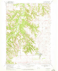
1969 Map of Rosebud
USGS Topo · Published 1972About this map
Rosebud serves as the focal point of this Todd County survey, situated within the bounds of the Rosebud Indian Reservation during the late 1960s. The landscape is defined by the drainage of Rosebud Creek and the prominent Rosebud Butte, showing a community organized around the Rosebud Ch and local civic infrastructure like the Radio Tower. Local recreational and agricultural life is evidenced by the Spotted Tail Golf Course, Indian Scout Lake, and the Tribal Ranch located along the West Branch Soldier Creek. Genealogists will find particular value in the location of the Spotted Tail Cem and another smaller Cem further south. The presence of the Paulhamous Landing Area indicates the importance of light aircraft for connecting this prairie terrain to larger hubs.
Find a feature on this map
19 named features on this map. Tap any name to fly to it.
Don’t see what you’re looking for? This feature index may not catch every label — zoom into the map to look around manually.
Map Details
Editions of this 1969 Rosebud Map
This is the sole edition of this map. No revisions or reprints were ever made.
Other maps of this area

1955 · Martin
USGS Topo · 1:250,000

1958 · Martin
USGS Topo · 1:250,000

1969 · Soldier Creek
USGS Topo · 1:24,000

1969 · Mission
USGS Topo · 1:24,000

1969 · Soldier Creek SE
USGS Topo · 1:24,000

1969 · Olsonville NW
USGS Topo · 1:24,000

1969 · St. Francis SW
USGS Topo · 1:24,000

1969 · Olsonville SW
USGS Topo · 1:24,000
1969 · St. Francis
USGS Topo · 1:24,000

1969 · St. Francis SE
USGS Topo · 1:24,000