
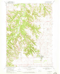
1969 Map of Soldier Creek SE
USGS Topo · Published 1972About this map
The Rosebud Indian Reservation landscape is defined here by the confluence of the White River and Little Oak Creek, where the terrain transitions from open plateau into a network of steep, eroded drainages. During the late 1960s, this area of Todd County maintained a distinct rural character centered on communal and spiritual sites like Ring Thunder Ch and the Native American Cem.
Find a feature on this map
14 named features on this map. Tap any name to fly to it.
Don’t see what you’re looking for? This feature index may not catch every label — zoom into the map to look around manually.
Map Details
Editions of this 1969 Soldier Creek SE Map
This is the sole edition of this map. No revisions or reprints were ever made.
Other maps of this area

1955 · Martin
USGS Topo · 1:250,000

1958 · Martin
USGS Topo · 1:250,000

1969 · Soldier Creek NE
USGS Topo · 1:24,000

1969 · Soldier Creek
USGS Topo · 1:24,000

1969 · Mission NW
USGS Topo · 1:24,000

1969 · Mission
USGS Topo · 1:24,000

1969 · Soldier Creek NW
USGS Topo · 1:24,000

1969 · Olsonville NW
USGS Topo · 1:24,000

1969 · Rosebud
USGS Topo · 1:24,000
1969 · St. Francis
USGS Topo · 1:24,000