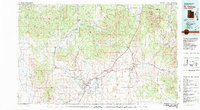
1980 Map of St. George
USGS Topo · Published 1981About this map
St George and its surrounding communities along the Virgin River are captured here during a period of notable growth in southwestern Utah. The map details the transition from established agricultural settlements like Santa Clara and Washington to newer developments such as Bloomington. The striking geological transition from the Pine Valley Mountains down to the Hurricane Cliffs is clearly delineated, showing how the local topography dictated the placement of early ranching outposts and infrastructure.
Find a feature on this map
69 named features on this map. Tap any name to fly to it.
Don’t see what you’re looking for? This feature index may not catch every label — zoom into the map to look around manually.
Map Details
Editions of this 1980 St. George Map
2 editions found
Other maps of this area

1885 · St. George
USGS Topo · 1:250,000

1885 · Pioche
USGS Topo · 1:250,000

1886 · Kanab
USGS Topo · 1:250,000

1886 · Saint Thomas
USGS Topo · 1:250,000

1886 · Mt. Trumbull
USGS Topo · 1:250,000

1886 · Pioche
USGS Topo · 1:250,000

1886 · Kaibab
USGS Topo · 1:250,000

1891 · St. George
USGS Topo · 1:250,000

1892 · Mt. Trumbull
USGS Topo · 1:250,000

1893 · Saint Thomas
USGS Topo · 1:250,000