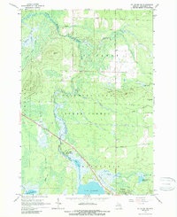
1965 Map of St. Helen NW
USGS Topo · Published 1989About this map
South Branch Au Sable River and its various tributaries define the landscape of this Roscommon County region in the mid-1960s. The map illustrates a transitional period for the area, where managed wilderness boundaries like the Houghton Lake State Forest and Higgins Lake State Forest intersect with critical infrastructure. The New York Central Railroad cuts a diagonal path across the terrain, passing the small settlement of Geels and providing a rail link through the densely wooded and marshy river valley toward St Helen.
Find a feature on this map
38 named features on this map. Tap any name to fly to it.
Don’t see what you’re looking for? This feature index may not catch every label — zoom into the map to look around manually.
Map Details
Editions of this 1965 St. Helen NW Map
2 editions found
Other maps of this area

1949 · Grayling
USGS Topo · 1:62,500

1950 · Roscommon North
USGS Topo · 1:24,000

1951 · Roscommon North
USGS Topo · 1:24,000

1954 · Traverse City
USGS Topo · 1:250,000

1958 · Traverse City
USGS Topo · 1:250,000

1963 · Luzerne
USGS Topo · 1:24,000

1963 · Roscommon South
USGS Topo · 1:24,000

1963 · Backus Lake
USGS Topo · 1:24,000

1963 · Eldorado
USGS Topo · 1:24,000

1965 · St. Helen NW
USGS Topo · 1:24,000