
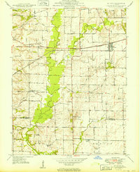
1949 Map of St. Jacob
USGS Topo · Published 1949About this map
St Jacob serves as the central hub of this agricultural and transit corridor in eastern Madison County, shortly after the Second World War. The town is anchored by the Pennsylvania Railroad railroad line, which cuts a straight path across the prairie, accompanied by clusters of Oil Wells that speak to the region's mid-century mineral production. The landscape is defined by the winding course of Silver Creek and its many tributaries, including Lake Fork and East Fork, which create a complex drainage pattern through the lowlands.
Find a feature on this map
47 named features on this map. Tap any name to fly to it.
Don’t see what you’re looking for? This feature index may not catch every label — zoom into the map to look around manually.
Map Details
Editions of this 1949 St. Jacob Map
2 editions found
Other maps of this area

1906 · Breese
USGS Topo · 1:62,500

1907 · Breese
USGS Topo · 1:62,500

1907 · Belleville
USGS Topo · 1:62,500

1927 · Edwardsville
USGS Topo · 1:62,500

1932 · Edwardsville
USGS Topo · 1:62,500

1935 · Lebanon
USGS Topo · 1:24,000

1937 · Collinsville
USGS Topo · 1:24,000

1937 · O'Fallon
USGS Topo · 1:24,000

1937 · New Douglas
USGS Topo · 1:48,000

1944 · New Douglas
USGS Topo · 1:62,500