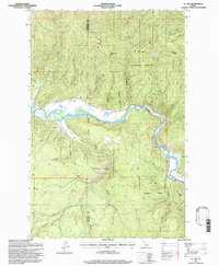
1995 Map of St. Joe
USGS Topo · Published 1997About this map
The St Joe River carves a winding path through the northern reaches of the St Joe National Forest in this mid-1990s revision. This mountainous region of Shoshone County is defined by its industrial and natural landmarks, most notably the Old Railroad Grade that traces the river's northern bank. High points such as Honey Jones Peak and Fitzgerald Peak overlook the valley, while the small settlement of St Joe serves as a primary point of human activity. The map reveals the intricate drainage system of the Idaho panhandle, including the clearings of Sly Meadows and the secluded Urquhart Lake. Further south, the terrain rises toward Gold Ridge and Coyote Butte, illustrating the area's timber and recreational value before the turn of the twenty-first century.
Find a feature on this map
33 named features on this map. Tap any name to fly to it.
Don’t see what you’re looking for? This feature index may not catch every label — zoom into the map to look around manually.
Map Details
Editions of this 1995 St. Joe Map
This is the sole edition of this map. No revisions or reprints were ever made.
Other maps of this area

1950 · Rochat Peak
USGS Topo · 1:24,000

1950 · Twin Crags
USGS Topo · 1:24,000

1952 · Rochat Peak
USGS Topo · 1:24,000

1952 · Twin Crags
USGS Topo · 1:24,000

1955 · Spokane
USGS Topo · 1:250,000

1957 · Calder
USGS Topo · 1:62,500

1957 · St. Joe
USGS Topo · 1:62,500

1958 · Spokane
USGS Topo · 1:250,000

1961 · Fernwood
USGS Topo · 1:62,500

1969 · Huckleberry Mtn
USGS Topo · 1:24,000