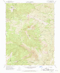
1968 Map of St. John Mtn.
USGS Topo · Published 1969About this map
Mendocino National Forest dominates this mid-century landscape, where a network of primitive transportation routes defines the high country. A system of pack trails and jeep trails connects established backcountry locations such as Meyers Cabin, Upper Nye Camp, and Happy Camp. The terrain is marked by sharp elevations, rising from Pleasant Valley in the east to the St John Mountain Radio Facility and the Sheetiron Mtn Lookout in the west.
Find a feature on this map
38 named features on this map. Tap any name to fly to it.
Don’t see what you’re looking for? This feature index may not catch every label — zoom into the map to look around manually.
Map Details
Editions of this 1968 St. John Mtn. Map
2 editions found
Other maps of this area

1919 · Elk Creek
USGS Topo · 1:62,500

1922 · Hullville
USGS Topo · 1:62,500

1948 · Elk Creek
USGS Topo · 1:62,500

1951 · Lake Pillsbury
USGS Topo · 1:62,500

1951 · Stonyford
USGS Topo · 1:62,500

1952 · Hull Mountain
USGS Topo · 1:62,500

1957 · Elk Creek
USGS Topo · 1:62,500

1957 · Ukiah
USGS Topo · 1:250,000

1960 · Ukiah
USGS Topo · 1:250,000
1967 · Potato Hill
USGS Topo · 1:24,000