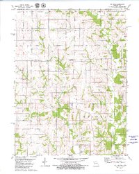
1979 Map of St. John
USGS Topo · Published 1980About this map
The Iowa Missouri state line bisects this 1979 survey, where the rural township structure of Wayne County and Putnam County meets. The small settlement of St John serves as the central focal point in Putnam County, surrounded by a landscape defined by the drainage systems of Locust Creek and West Fork Locust Creek. The terrain is characterized by the branching networks of West Locust Creek and Elm Branch, which have shaped the local agricultural boundaries and road placements.
Find a feature on this map
13 named features on this map. Tap any name to fly to it.
Don’t see what you’re looking for? This feature index may not catch every label — zoom into the map to look around manually.
Map Details
Editions of this 1979 St. John Map
This is the sole edition of this map. No revisions or reprints were ever made.
Other maps of this area

1942 · Seymour
USGS Topo · 1:62,500

1944 · Seymour
USGS Topo · 1:62,500

1954 · Centerville
USGS Topo · 1:250,000

1957 · Centerville
USGS Topo · 1:250,000

1958 · Centerville
USGS Topo · 1:250,000

1964 · Pollock NW
USGS Topo · 1:24,000

1964 · Unionville West
USGS Topo · 1:24,000

1964 · Lucerne
USGS Topo · 1:24,000

1964 · Allerton
USGS Topo · 1:24,000
1964 · Powersville
USGS Topo · 1:24,000