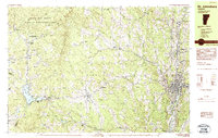
1983 Map of St. Johnsbury
USGS Topo · Published 1983About this map
The Passumpsic River and Moose River converge at St Johnsbury, a vital industrial and transit hub in northeastern Vermont as it appeared in the early 1980s. This survey illustrates the dense settlement pattern of the river valley contrasted with the upland farming and logging terrain of the Kittredge Hills. Transportation is a dominant theme, showing the Canadian Pacific rail line threading through the landscape alongside modern interstate developments marked by Interchange 22 and Interchange 21.
Find a feature on this map
79 named features on this map. Tap any name to fly to it.
Don’t see what you’re looking for? This feature index may not catch every label — zoom into the map to look around manually.
Map Details
Editions of this 1983 St. Johnsbury Map
2 editions found
Other maps of this area

1928 · Hardwick
USGS Topo · 1:62,500

1931 · Littleton
USGS Topo · 1:62,500

1932 · Littleton
USGS Topo · 1:48,000

1934 · Hardwick
USGS Topo · 1:48,000

1935 · Littleton
USGS Topo · 1:62,500

1935 · Lyndonville
USGS Topo · 1:48,000

1938 · Hardwick
USGS Topo · 1:62,500

1938 · St. Johnsbury
USGS Topo · 1:48,000

1939 · Lyndonville
USGS Topo · 1:62,500

1939 · Plainfield
USGS Topo · 1:48,000