Loading...
Loading map...1924 Map of St. Joseph
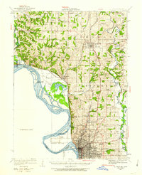
USGS Topo · Published 1962About this map
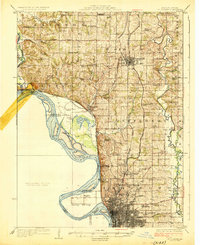
The Missouri River and its expansive floodplain dominate this survey of Northwest Missouri, where the river's winding course creates distinct landforms like Nodaway Island and the French Bottom. To the south, the city of St. Joseph is shown in significant detail, including the grid of the City Waterworks and the grounds of the State Hospital. The surrounding countryside in Buchanan and Andrew counties is characterized by a dense network of country schools and churches that served the agricultural community in the early 1920s.
Find a feature on this map
70 named features on this map. Tap any name to fly to it.
Don’t see what you’re looking for? This feature index may not catch every label — zoom into the map to look around manually.
Map Details
Date Portrayed1924
Date Published1962
PublisherU.S. Geological Survey
Map TypeTopographic
Scale1:62,500
Physical Dimensions16.9 x 20.8 inches
Editions of this 1924 St. Joseph Map
2 editions found

Historical Maps of Saint Joseph Through Time
Featured Locations
Source Details
SourceU.S. Geological Survey
CopyrightPublic Domain