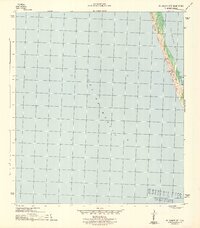
1943 Map of St. Joseph Spit
USGS Topo · Published 1943About this map
St Joseph Spit stretches along the Florida coast during the Second World War, serving as a narrow barrier between the open Gulf of Mexico and the sheltered waters of St Joseph Bay. Produced by the U. S. Geological Survey under the direction of the War Department, this 1943 survey documents a nearly pristine coastal environment. The map highlights the dynamic nature of this barrier landform, specifically noting the presence of Sand Dunes that define the spit's topography. At the southern interior of the spit, the small inlet of Pig Bayou provides a rare point of reference in an otherwise undeveloped landscape. This document preserves the physical state of the Gulf County shoreline before later 20th-century developments, providing a clear record of the natural hazards and geography that would have been critical for wartime coastal defense planning.
Find a feature on this map
5 named features on this map. Tap any name to fly to it.
Don’t see what you’re looking for? This feature index may not catch every label — zoom into the map to look around manually.
Map Details
Editions of this 1943 St. Joseph Spit Map
4 editions found
Other maps of this area

1943 · St Joseph Spit
USGS Topo · 1:31,680

1943 · Port St. Joe
USGS Topo · 1:31,680

1943 · Cape San Blas
USGS Topo · 1:31,680

1945 · St Joseph Point
USGS Topo · 1:31,680

1949 · Apalachicola
USGS Topo · 1:250,000

1957 · Apalachicola
USGS Topo · 1:250,000

1959 · Apalachicola
USGS Topo · 1:250,000
1960 · Apalachicola
USGS Topo · 1:250,000
1967 · Apalachicola
USGS Topo · 1:250,000
1978 · Port Saint Joe
USGS Topo · 1:100,000