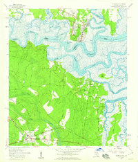
1958 Map of St. Marys
USGS Topo · Published 1959About this map
St Marys, Georgia, serves as a focal point in this late 1950s study of the riverine border with Florida. The landscape is defined by the sinuous path of the St Marys River, which separates Camden County from Nassau County amidst a network of tidal waterways including the Bells River and Jolly River. This era shows the region's transportation reliance on the Seaboard Air Line railroad and the Buccaneer Trail, which intersect near the community of Yulee. Notable local institutions like the Bryant Academy and several country churches, such as Mt Zion Ch and New Hope Ch, provide a window into the social fabric of the period. The presence of Reids Bluff and Roses Bluff highlights the subtle elevation changes along the riverbanks, while the St Marys Airport marks the encroaching modern infrastructure of the mid-century south.
Find a feature on this map
37 named features on this map. Tap any name to fly to it.
Don’t see what you’re looking for? This feature index may not catch every label — zoom into the map to look around manually.
Map Details
Editions of this 1958 St. Marys Map
Other maps of this area

1918 · St Marys
USGS Topo · 1:62,500

1918 · Cumberland Island
USGS Topo · 1:62,500

1918 · Kingsland
USGS Topo · 1:62,500

1919 · Fernandina
USGS Topo · 1:62,500

1919 · St Marys
USGS Topo · 1:62,500

1930 · Cumberland Island
USGS Topo · 1:62,500

1944 · Fernandina
USGS Topo · 1:62,500

1945 · Cumberland Island
USGS Topo · 1:62,500

1948 · Jacksonville
USGS Topo · 1:250,000

1957 · Jacksonville
USGS Topo · 1:250,000