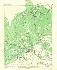
1935 Map of St Paul
USGS Topo · Published 1935About this map
Coal and iron transport dominate the landscape where the Clinchfield Railroad and Norfolk and Western Railway converge. The industrial character of the mid-1930s is visible in the heavy concentration of rail infrastructure, including the Lonesome Pine Tunnel, Craigen Tunnel, and the expansive Crusher Yard near St Paul. Settlement patterns follow the narrow valleys and ridges, with the mining community of Dante tucked under Sandy Ridge and West Dante situated near Austin Gap. Local life is anchored by numerous rural institutions such as Temple Hill Sch, Gose Sch, and Zion Ch. The Clinch River meanders sharply through the southern portion of the map, carving deep bends near Burtons Ford and Castlewood. This map captures a pivotal era of extraction and rail-driven commerce in Southwest Virginia.
Find a feature on this map
76 named features on this map. Tap any name to fly to it.
Don’t see what you’re looking for? This feature index may not catch every label — zoom into the map to look around manually.
Map Details
Editions of this 1935 St Paul Map
This is the sole edition of this map. No revisions or reprints were ever made.
Other maps of this area

1886 · Grundy
USGS Topo · 1:125,000

1890 · Grundy
USGS Topo · 1:125,000

1892 · Grundy
USGS Topo · 1:125,000

1897 · Bristol
USGS Topo · 1:125,000

1902 · Bristol
USGS Topo · 1:125,000

1913 · Clintwood
USGS Topo · 1:62,500

1914 · Bucu
USGS Topo · 1:48,000

1915 · Clintwood
USGS Topo · 1:62,500

1916 · Bucu
USGS Topo · 1:62,500

1918 · Carterton
USGS Topo · 1:62,500