
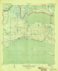
1945 Map of St. Teresa
USGS Topo · Published 1960About this map
St Teresa sits along the northern edge of Alligator Harbor, serving as a coastal outpost at a time when much of the surrounding Franklin and Wakulla County line remained undeveloped wetlands and coastal marshes. This mid-century survey illustrates the intricate drainage systems of the Ochlockonee River, where the Sopchoppy River and the Dead River converge near Thorn Island and Grass Island. The northern reach is dominated by the St Marks National Wildlife Refuge, preserving a complex landscape of hammocks and lakes including Corn Landing Lake and Halfway Lake. Further south, the protective barrier of Peninsula Point separates the calm harbor from the open Gulf of Mexico, terminating at the distinct Southwest Cape. The map records the early alignment of State Road 10 and U.S. 319 as they navigate the tidal creeks and low-lying points like Simmons Point and Turkey Point.
Find a feature on this map
30 named features on this map. Tap any name to fly to it.
Don’t see what you’re looking for? This feature index may not catch every label — zoom into the map to look around manually.
Map Details
Editions of this 1945 St. Teresa Map
3 editions found
Historical Maps of Surf Through Time
121 maps found

1943 Dog Island
Franklin County, FL

1943 Indian Pass
Franklin County, FL

1943 Lighthouse Point
Franklin County, FL

1943 St. Teresa Beach
Franklin County, FL

1943 West Pass
Franklin County, FL

1944 Green Point
Franklin County, FL

1944 Pickett Bay
Franklin County, FL

1944 Sugar Hill
Franklin County, FL

1945 Beverly
Franklin County, FL

1945 Cape St. George
Franklin County, FL

1945 Fort Gadsden
Franklin County, FL

1945 Indian Pass
Franklin County, FL

1945 Lighthouse Point
Franklin County, FL

1945 Mc Intyre
Franklin County, FL

1945 Pickett Bay
Franklin County, FL
1945 St. Teresa
Franklin County, FL

1945 Sugar Hill
Franklin County, FL

1945 Tates Hell Swamp
Franklin County, FL

1950 Goose Island
Franklin County, FL

1950 New Inlet
Franklin County, FL

1981 Beverly
Franklin County, FL

1981 Fort Gadsden
Franklin County, FL

1981 Goose Island
Franklin County, FL

1981 New Inlet
Franklin County, FL

1981 Pickett Bay
Franklin County, FL

1981 St. Teresa
Franklin County, FL

1981 Sugar Hill
Franklin County, FL

1981 Tates Hell Swamp
Franklin County, FL

1982 Cape St George
Franklin County, FL

1982 Dog Island
Franklin County, FL

1982 Green Point
Franklin County, FL

1982 Indian Pass
Franklin County, FL

1982 Lighthouse Point
Franklin County, FL

1982 McIntyre
Franklin County, FL

1982 West Pass
Franklin County, FL

1994 Dog Island
Franklin County, FL

2012 Beverly
Franklin County, FL

2012 Cape Saint George
Franklin County, FL

2012 Dog Island
Franklin County, FL

2012 Fort Gadsden
Franklin County, FL

2012 Goose Island
Franklin County, FL

2012 Green Point
Franklin County, FL

2012 Indian Pass
Franklin County, FL

2012 Lighthouse Point
Franklin County, FL

2012 McIntyre
Franklin County, FL

2012 New Inlet
Franklin County, FL

2012 Pickett Bay
Franklin County, FL

2012 Saint Teresa
Franklin County, FL

2012 Sugar Hill
Franklin County, FL

2012 Tates Hell Swamp
Franklin County, FL

2012 West Pass
Franklin County, FL

2015 Beverly
Franklin County, FL

2015 Cape Saint George
Franklin County, FL

2015 Dog Island
Franklin County, FL

2015 Fort Gadsden
Franklin County, FL

2015 Goose Island
Franklin County, FL

2015 Green Point
Franklin County, FL

2015 Indian Pass
Franklin County, FL

2015 Lighthouse Point
Franklin County, FL

2015 McIntyre
Franklin County, FL

2015 New Inlet
Franklin County, FL

2015 Pickett Bay
Franklin County, FL

2015 Saint Teresa
Franklin County, FL

2015 Sugar Hill
Franklin County, FL

2015 Tates Hell Swamp
Franklin County, FL

2015 West Pass
Franklin County, FL

2018 Beverly
Franklin County, FL

2018 Cape Saint George
Franklin County, FL

2018 Dog Island
Franklin County, FL

2018 Fort Gadsden
Franklin County, FL

2018 Goose Island
Franklin County, FL

2018 Green Point
Franklin County, FL

2018 Indian Pass
Franklin County, FL

2018 Lighthouse Point
Franklin County, FL

2018 McIntyre
Franklin County, FL

2018 New Inlet
Franklin County, FL

2018 Pickett Bay
Franklin County, FL

2018 Saint Teresa
Franklin County, FL

2018 Sugar Hill
Franklin County, FL

2018 Tates Hell Swamp
Franklin County, FL

2018 West Pass
Franklin County, FL

2021 Beverly
Franklin County, FL

2021 Cape Saint George
Franklin County, FL

2021 Dog Island
Franklin County, FL

2021 Fort Gadsden
Franklin County, FL

2021 Goose Island
Franklin County, FL

2021 Green Point
Franklin County, FL

2021 Indian Pass
Franklin County, FL

2021 Lighthouse Point
Franklin County, FL

2021 McIntyre
Franklin County, FL

2021 New Inlet
Franklin County, FL

2021 Pickett Bay
Franklin County, FL

2021 Saint Teresa
Franklin County, FL

2021 Sugar Hill
Franklin County, FL

2021 Tates Hell Swamp
Franklin County, FL

2021 West Pass
Franklin County, FL

2024 Beverly
Franklin County, FL

2024 Cape Saint George
Franklin County, FL

2024 Dog Island
Franklin County, FL

2024 Fort Gadsden
Franklin County, FL

2024 Goose Island
Franklin County, FL

2024 Green Point
Franklin County, FL

2024 Indian Pass
Franklin County, FL

2024 Lighthouse Point
Franklin County, FL

2024 McIntyre
Franklin County, FL

2024 New Inlet
Franklin County, FL

2024 Pickett Bay
Franklin County, FL

2024 Saint Teresa
Franklin County, FL

2024 Sugar Hill
Franklin County, FL

2024 Tates Hell Swamp
Franklin County, FL

2024 West Pass
Franklin County, FL

2025 Cape Saint George
Franklin County, FL

2025 Dog Island
Franklin County, FL

2025 Goose Island
Franklin County, FL

2025 Indian Pass
Franklin County, FL

2025 Lighthouse Point
Franklin County, FL

2025 McIntyre
Franklin County, FL

2025 New Inlet
Franklin County, FL

2025 Saint Teresa
Franklin County, FL

2025 Sugar Hill
Franklin County, FL

2025 West Pass
Franklin County, FL