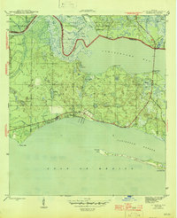
1945 Map of St Teresa
USGS Topo · Published 1945About this map
St Teresa sits at the heart of this mid-1940s coastal survey, established along the northern edge of Alligator Harbor. The landscape is dominated by a complex network of waterways where the Ochlockonee River and Sopchoppy River converge into the broad expanse of Ochlockonee Bay. This estuarine environment is defined by low-lying islands like Thom Island and Grass Island, and sheltered points including Simmons Point and Granit Point.
Find a feature on this map
30 named features on this map. Tap any name to fly to it.
Don’t see what you’re looking for? This feature index may not catch every label — zoom into the map to look around manually.
Map Details
Editions of this 1945 St Teresa Map
3 editions found
Other maps of this area

1940 · Arran
USGS Topo · 1:62,500

1943 · Arran
USGS Topo · 1:62,500

1943 · Dog Island
USGS Topo · 1:31,680

1943 · St. Teresa Beach
USGS Topo · 1:24,000

1943 · Lighthouse Point
USGS Topo · 1:24,000

1945 · Lighthouse Point
USGS Topo · 1:31,680

1945 · Mc Intyre
USGS Topo · 1:31,680

1945 · St Teresa
USGS Topo · 1:31,680

1945 · Sanborn
USGS Topo · 1:31,680

1949 · Apalachicola
USGS Topo · 1:250,000