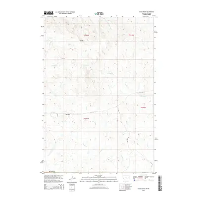
2014 Map of Stack Rocks
USGS Topo · Published 2014About this map
Stack Rocks and the distinctive Rock Wall define the high terrain of Carter County in this modern topographic study of southeastern Montana. The landscape is deeply etched by a complex network of seasonal drainages, most notably the E Fork Little Powder River which flows through the northeastern corner. Ranching and access routes are concentrated along several named tracks, including Alzada Ridge Rd and Dingmans Rd, which navigate the various ridges between Coal Cr and Thompson Cr. The drainage patterns of N Thompson Cr and Short Cr reveal the intricate erosion of this high plains environment, offering a clear view of the natural water distribution and land management boundaries within the Public Land Survey System sections.
Find a feature on this map
15 named features on this map. Tap any name to fly to it.
Don’t see what you’re looking for? This feature index may not catch every label — zoom into the map to look around manually.
Map Details
Editions of this 2014 Stack Rocks Map
This is the sole edition of this map. No revisions or reprints were ever made.
Other maps of this area
1905 · Devils Tower
USGS Topo · 1:125,000

1954 · Ekalaka
USGS Topo · 1:250,000

1954 · Gillette
USGS Topo · 1:250,000

1955 · Gillette
USGS Topo · 1:250,000

1956 · Ekalaka
USGS Topo · 1:250,000
1957 · Cedar Ridge
USGS Topo · 1:62,500

1958 · Gillette
USGS Topo · 1:250,000

1958 · Ekalaka
USGS Topo · 1:250,000

1962 · Gillette
USGS Topo · 1:250,000

1965 · Ekalaka
USGS Topo · 1:250,000