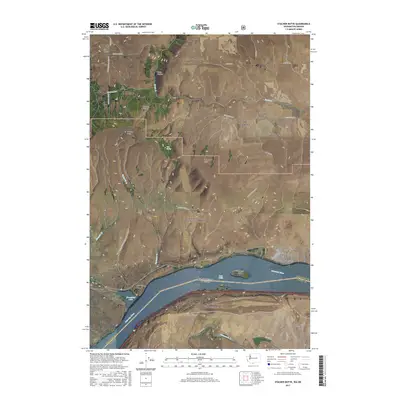
2017 Map of Stacker Butte
USGS Topo · Published 2017About this map
High Prairie and Gooseneck sit atop the high plateaus of Klickitat County, overlooking a dramatic landscape where the Columbia Hills descend toward the river. This survey captures the topographical transition from the agricultural lands along Centerville Hwy to the steep, carved environments of Stacker Canyon and Swale Canyon. To the south, the Columbia River serves as the interstate boundary, featuring Lake Celilo and Browns Island. Significant elevation changes are marked by Stacker Butte and the distinct formation of Horsethief Butte near the water's edge. The map also delineates the northern reaches of the Mount Hood National Forest and the southern edge of the Gifford Pinchot National Forest, highlighting the vast public lands that dominate this portion of the Pacific Northwest. Local transit is defined by winding routes like Dalles Mountain Rd and Wankiacus High Prairie Rd, which navigate the complex ridges and gaps.
Find a feature on this map
39 named features on this map. Tap any name to fly to it.
Don’t see what you’re looking for? This feature index may not catch every label — zoom into the map to look around manually.
Map Details
Editions of this 2017 Stacker Butte Map
This is the sole edition of this map. No revisions or reprints were ever made.
Other maps of this area

1934 · The Dalles
USGS Topo · 1:125,000

1953 · The Dalles
USGS Topo · 1:250,000

1956 · The Dalles
USGS Topo · 1:250,000

1957 · The Dalles
USGS Topo · 1:250,000

1957 · Klickitat
USGS Topo · 1:62,500

1957 · Goldendale
USGS Topo · 1:62,500

1957 · The Dalles
USGS Topo · 1:62,500

1957 · Wishram
USGS Topo · 1:62,500

1974 · Stacker Butte
USGS Topo · 1:24,000

1974 · The Dalles North
USGS Topo · 1:24,000