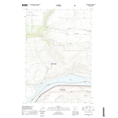
2020 Map of Stacker Butte
USGS Topo · Published 2020About this map
The Columbia Hills dominate the terrain of this quadrangle, forming a sharp divide between the agricultural plateaus to the north and the water-carved gorge of the Columbia River. In the northern reaches, the settlements of High Prairie and Gooseneck are situated among a network of rural roads like Schilling Rd and Centerville Hwy. The landscape is deeply incised by drainages such as Stacker Canyon and Swale Canyon, which funnel toward the river. Along the southern boundary, the river itself is represented by Lake Celilo, where Browns Island and Horsethief Butte stand as prominent landmarks. This 2020 survey illustrates a complex boundary zone where the Gifford Pinchot National Forest and Mount Hood National Forest meet the Washington-Oregon state line. Modern infrastructure like the Klickitat State Park-Trail follows the path of former rail corridors, while historic paths like the Military Road and Brune Trail trace earlier human movement through these high ridges.
Find a feature on this map
44 named features on this map. Tap any name to fly to it.
Don’t see what you’re looking for? This feature index may not catch every label — zoom into the map to look around manually.
Map Details
Editions of this 2020 Stacker Butte Map
This is the sole edition of this map. No revisions or reprints were ever made.
Other maps of this area

1934 · The Dalles
USGS Topo · 1:125,000

1953 · The Dalles
USGS Topo · 1:250,000

1956 · The Dalles
USGS Topo · 1:250,000

1957 · The Dalles
USGS Topo · 1:250,000

1957 · Klickitat
USGS Topo · 1:62,500

1957 · Goldendale
USGS Topo · 1:62,500

1957 · The Dalles
USGS Topo · 1:62,500

1957 · Wishram
USGS Topo · 1:62,500

1974 · Stacker Butte
USGS Topo · 1:24,000

1974 · The Dalles North
USGS Topo · 1:24,000