
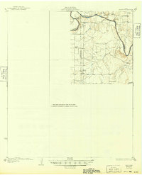
1931 Map of Stacy
USGS Topo · Published 1931About this map
The Colorado River winds through the heart of this Central Texas landscape, defining the boundaries where Coleman, Concho, and McCulloch counties meet. Surveyed in the mid-1920s, the terrain is shaped by a dense network of drainages including Mercury Creek, Panther Creek, and Salt Creek, which flow toward the river's deep bends. The settlement at Stacy and the nearby community of Doole serve as the primary hubs in an area dominated by rural ranching and early school districts.
Find a feature on this map
16 named features on this map. Tap any name to fly to it.
Don’t see what you’re looking for? This feature index may not catch every label — zoom into the map to look around manually.
Map Details
Editions of this 1931 Stacy Map
2 editions found
Other maps of this area

1887 · Coleman
USGS Topo · 1:125,000

1889 · Coleman
USGS Topo · 1:125,000

1892 · Eden
USGS Topo · 1:125,000

1892 · Ballinger
USGS Topo · 1:125,000

1894 · Brady
USGS Topo · 1:125,000

1896 · Eden
USGS Topo · 1:125,000

1924 · Eden 1-a
USGS Topo · 1:48,000

1925 · Brady 2-b
USGS Topo · 1:48,000

1925 · Ballinger 3-d
USGS Topo · 1:48,000

1925 · Ballinger 4-c
USGS Topo · 1:48,000