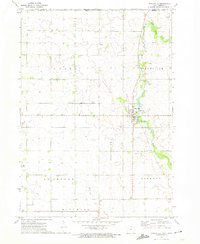
1972 Map of Stacyville
USGS Topo · Published 1974About this map
The Little Cedar River meanders south from the Minnesota Iowa border, anchoring the landscape of northeastern Mitchell County during the early 1970s. The town of Stacyville serves as the central hub, situated where the Illinois Central Gulf railroad line meets the river. This period shows a community deeply tied to both its agricultural roots and local industry, evidenced by the numerous Gravel Pits and a Quarry dotting the township lines.
Find a feature on this map
20 named features on this map. Tap any name to fly to it.
Don’t see what you’re looking for? This feature index may not catch every label — zoom into the map to look around manually.
Map Details
Editions of this 1972 Stacyville Map
This is the sole edition of this map. No revisions or reprints were ever made.
Other maps of this area

1954 · Austin
USGS Topo · 1:62,500

1954 · Mason City
USGS Topo · 1:250,000

1957 · Mason City
USGS Topo · 1:250,000

1958 · Mason City
USGS Topo · 1:250,000

1965 · Adams
USGS Topo · 1:24,000

1972 · Osage
USGS Topo · 1:24,000

1972 · St. Ansgar
USGS Topo · 1:24,000

1972 · Little Cedar
USGS Topo · 1:24,000

1972 · New Haven
USGS Topo · 1:24,000

1972 · Osage SW
USGS Topo · 1:24,000