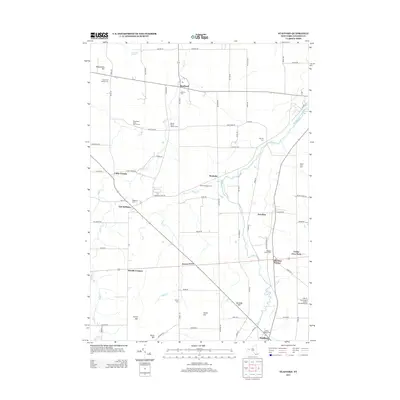
2013 Map of Stafford
USGS Topo · Published 2013About this map
The agricultural and rural landscape of eastern Genesee County is defined by the winding paths of Black Cr and Oatka Cr. Long-established settlements such as Stafford and Roanoke anchor a network of country roads, where the economy remains tied to the land at Roanoke Apple Farms and Millers Fruit Farm. The terrain is punctuated by several prominent rises, including Temperance Hill in the northwest and Skunk Hill to the south, while recreational spaces like Sweetland Pines Golf Course and Bel-Air Ranch Health Camp dot the countryside.
Find a feature on this map
80 named features on this map. Tap any name to fly to it.
Don’t see what you’re looking for? This feature index may not catch every label — zoom into the map to look around manually.
Map Details
Editions of this 2013 Stafford Map
This is the sole edition of this map. No revisions or reprints were ever made.
Other maps of this area

1897 · Albion
USGS Topo · 1:62,500

1899 · Brockport
USGS Topo · 1:62,500

1904 · Batavia
USGS Topo · 1:62,500

1904 · Caledonia
USGS Topo · 1:62,500

1935 · Churchville
USGS Topo · 1:24,000

1944 · Churchville
USGS Topo · 1:31,680

1944 · Byron
USGS Topo · 1:31,680

1944 · Stafford
USGS Topo · 1:31,680
1944 · Le Roy
USGS Topo · 1:31,680
1944 · Leicester
USGS Topo · 1:31,680