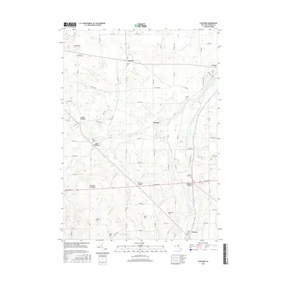
2016 Map of Stafford
USGS Topo · Published 2016About this map
Stafford and Le Roy anchor this landscape of western New York, where the agricultural grid is intersected by the winding paths of Black Cr and Oatka Creek. The map reveals a high density of burial grounds, including the Pioneer Cem and the uniquely named Jug City Cem, which serve as vital markers for genealogical research in Genesee County. Smaller settlements such as Roanoke, East Bethany, and Pavilion Center are connected by a network of rural routes like Clipnock Rd and Transit Rd. Local landmarks including Temperance Hill and Skunk Hill rise above the creek valleys, while the intriguing names of Suicide Corners and Texaco Town suggest a rich layer of local lore and naming conventions. The landscape remains defined by its watercourses, particularly White Cr, which feeds into the larger regional drainage patterns.
Find a feature on this map
74 named features on this map. Tap any name to fly to it.
Don’t see what you’re looking for? This feature index may not catch every label — zoom into the map to look around manually.
Map Details
Editions of this 2016 Stafford Map
This is the sole edition of this map. No revisions or reprints were ever made.
Other maps of this area

1897 · Albion
USGS Topo · 1:62,500

1899 · Brockport
USGS Topo · 1:62,500

1904 · Batavia
USGS Topo · 1:62,500

1904 · Caledonia
USGS Topo · 1:62,500

1935 · Churchville
USGS Topo · 1:24,000

1944 · Churchville
USGS Topo · 1:31,680

1944 · Byron
USGS Topo · 1:31,680

1944 · Stafford
USGS Topo · 1:31,680
1944 · Le Roy
USGS Topo · 1:31,680
1944 · Leicester
USGS Topo · 1:31,680