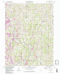
1994 Map of Stafford
USGS Topo · Published 1998About this map
The rugged topography of the Wayne National Forest defines the landscape where Noble and Monroe counties meet. This mid-1990s record of the area reveals a deeply dissected terrain characterized by high ridges like Crum Ridge and Creighton Ridge, which separate the various branches of the East Fork Duck Creek. The settlement pattern is concentrated in the valley floors and along high points, with Stafford and Harriettsville serving as primary hubs. Local life is anchored by institutions like the Mt Tabor Ch, Township Sch, and several remote burial grounds including Zion Cem and Stewart Cem. Evidence of the region’s extractive history is prominent, with numerous Strip Mines and isolated Mine locations dotting the hillsides, particularly near Carlisle. Small-scale industrial infrastructure, such as a Pumping Sta, suggests the continued importance of local resource management within this forested corner of Ohio.
Find a feature on this map
35 named features on this map. Tap any name to fly to it.
Don’t see what you’re looking for? This feature index may not catch every label — zoom into the map to look around manually.
Map Details
Editions of this 1994 Stafford Map
This is the sole edition of this map. No revisions or reprints were ever made.
Other maps of this area

1903 · Macksburg
USGS Topo · 1:62,500

1905 · New Matamoras
USGS Topo · 1:62,500

1905 · Woodsfield
USGS Topo · 1:62,500

1905 · Macksburg
USGS Topo · 1:62,500

1909 · Summerfield
USGS Topo · 1:62,500

1911 · Summerfield
USGS Topo · 1:62,500

1924 · New Matamoras
USGS Topo · 1:62,500

1926 · New Matamoras
USGS Topo · 1:62,500

1949 · Clarksburg
USGS Topo · 1:250,000

1956 · Clarksburg
USGS Topo · 1:250,000