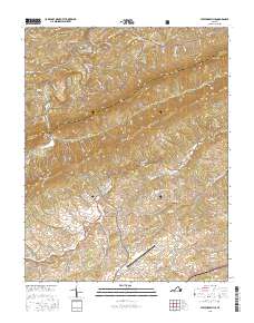
2016 Map of Staffordsville
USGS Topo · Published 2016About this map
Cloyds Mtn and Little Walker Mtn dominate the central topography of this portion of Southwest Virginia, creating a corridor of ridges and valleys that define local settlement. Within the Jefferson National Forest, small rural communities like Staffordsville, Trigg, and Poplar Hill are linked by a network of winding mountain roads such as Springdale Rd and Staffordsville Hill Rd. The map illustrates the region's reliance on valley drainage systems, with Walker Creek and its many tributaries, including Little Walker Creek and Back Creek, carving out the habitable lowlands.
Find a feature on this map
72 named features on this map. Tap any name to fly to it.
Don’t see what you’re looking for? This feature index may not catch every label — zoom into the map to look around manually.
Map Details
Editions of this 2016 Staffordsville Map
This is the sole edition of this map. No revisions or reprints were ever made.
Other maps of this area

1890 · Dublin
USGS Topo · 1:125,000

1891 · Dublin
USGS Topo · 1:125,000

1913 · Peterstown
USGS Topo · 1:48,000

1916 · Peterstown
USGS Topo · 1:62,500

1923 · Pearisburg
USGS Topo · 1:62,500

1925 · Peterstown
USGS Topo · 1:62,500

1932 · Peterstown
USGS Topo · 1:48,000

1932 · Pearisburg
USGS Topo · 1:48,000

1934 · Pulaski
USGS Topo · 1:48,000

1937 · Pearisburg
USGS Topo · 1:62,500