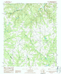
1986 Map of Staley Crossroads
USGS Topo · Published 1986About this map
Staley Crossroads serves as a central landmark in this mid-1980s landscape where the borders of Lexington, Calhoun, and Orangeburg counties converge. The terrain is defined by an intricate network of drainage and local water bodies, including Big Beaver Creek to the north and the extensive Caw Caw Swamp and Cowpen Swamp systems. Family-named water features like Culclasure Pond, Gressette Pond, Redmond Pond, and Rast Pond suggest a history of private landownership and agricultural water management typical of the South Carolina Midlands during this era. Scattered Cem (cemetery) labels and the presence of a Wooden H-Frame Trans Line indicate a rural infrastructure that balances historic family plots with the development of utility corridors. The map provides a detailed view of the rural transition from natural creek bottoms like Limestone Creek and Rock Branch to the settled crossroads that once anchored local commerce and transit.
Find a feature on this map
25 named features on this map. Tap any name to fly to it.
Don’t see what you’re looking for? This feature index may not catch every label — zoom into the map to look around manually.
Map Details
Editions of this 1986 Staley Crossroads Map
This is the sole edition of this map. No revisions or reprints were ever made.
Other maps of this area

1944 · Edmund
USGS Topo · 1:62,500

1946 · Woodford
USGS Topo · 1:62,500

1946 · St. Matthews
USGS Topo · 1:62,500

1948 · Hopkins
USGS Topo · 1:62,500

1953 · Saylors Lake
USGS Topo · 1:24,000

1953 · Gadsden
USGS Topo · 1:24,000

1954 · Augusta
USGS Topo · 1:250,000

1957 · Augusta
USGS Topo · 1:250,000

1958 · Augusta
USGS Topo · 1:250,000

1961 · Augusta
USGS Topo · 1:250,000