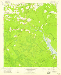
1957 Map of Stallsville
USGS Topo · Published 1959About this map
The Ashley River corridor in Dorchester County is defined by a deep colonial and agricultural history, seen here during the mid-century. The landscape transitions from the small residential clusters at Stallsville and Centerville into a terrain of sprawling hunt clubs and wetland savannas, such as Round Savanna and Horse Savanna. Along the riverbanks, the presence of Old Fort Dorchester and several historic congregations, including St Lukes Ch and White Church Cem, points to the region's long-established settlement patterns.
Find a feature on this map
42 named features on this map. Tap any name to fly to it.
Don’t see what you’re looking for? This feature index may not catch every label — zoom into the map to look around manually.
Map Details
Editions of this 1957 Stallsville Map
3 editions found
Other maps of this area

1918 · Cottageville
USGS Topo · 1:62,500

1919 · Ladson
USGS Topo · 1:21,120

1919 · Johns Island
USGS Topo · 1:21,120

1919 · Summerville
USGS Topo · 1:48,000

1919 · Ridgeville
USGS Topo · 1:48,000

1920 · Ravenels
USGS Topo · 1:62,500

1920 · Ridgeville
USGS Topo · 1:62,500

1920 · Summerville
USGS Topo · 1:62,500

1943 · Cottageville
USGS Topo · 1:62,500

1943 · Ladson
USGS Topo · 1:24,000