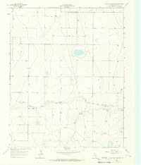
1965 Map of Stallwitz Lake NE
USGS Topo · Published 1966About this map
South Palo Duro Creek winds across this Moore County landscape, serving as the primary drainage for an area defined by the mid-century expansion of the Texas energy sector. While the terrain remains largely open range, the proliferation of Gas Wells and Oil Wells across the grid indicates the intensity of mineral extraction in the mid-1960s. The presence of a major Pipeline and scattered Gravel Pits further emphasizes an industrial landscape centered on natural resources rather than residential settlements. This survey, conducted using photogrammetric methods from 1962 aerial photography and 1965 planetable surveys, documents the transition of the High Plains into a highly managed industrial field where the natural meanders of the creek contrast with the straight lines of modern infrastructure.
Find a feature on this map
5 named features on this map. Tap any name to fly to it.
Don’t see what you’re looking for? This feature index may not catch every label — zoom into the map to look around manually.
Map Details
Editions of this 1965 Stallwitz Lake NE Map
This is the sole edition of this map. No revisions or reprints were ever made.
Other maps of this area

1954 · Tucumcari
USGS Topo · 1:250,000

1954 · Perryton
USGS Topo · 1:250,000

1954 · Amarillo
USGS Topo · 1:250,000

1954 · Dalhart
USGS Topo · 1:250,000

1958 · Perryton
USGS Topo · 1:250,000

1958 · Amarillo
USGS Topo · 1:250,000

1958 · Tucumcari
USGS Topo · 1:250,000

1958 · Dalhart
USGS Topo · 1:250,000

1962 · Dalhart
USGS Topo · 1:250,000

1963 · Cactus East
USGS Topo · 1:24,000