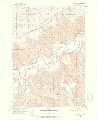
1951 Map of Stamford SW
USGS Topo · Published 1952About this map
The White River carves a winding path through this western South Dakota landscape, serving as a natural boundary between several counties. To the south, the Pine Ridge Indian Reservation occupies a significant portion of the territory, with the Reservation Boundary clearly delineated. Educational history is preserved through the locations of the Srb School and the Valley Sch (Abandoned), the latter reflecting shifting settlement patterns in the mid-20th century.
Find a feature on this map
16 named features on this map. Tap any name to fly to it.
Don’t see what you’re looking for? This feature index may not catch every label — zoom into the map to look around manually.
Map Details
Editions of this 1951 Stamford SW Map
3 editions found
Other maps of this area

1951 · Stamford SW
USGS Topo · 1:24,000

1951 · Belvidere
USGS Topo · 1:24,000

1951 · Stamford SE
USGS Topo · 1:24,000

1951 · Cedar Butte NW
USGS Topo · 1:24,000

1951 · Cedar Butte NE
USGS Topo · 1:24,000

1951 · Pass Creek NE
USGS Topo · 1:24,000

1953 · Belvidere NE
USGS Topo · 1:24,000

1955 · Martin
USGS Topo · 1:250,000

1958 · Martin
USGS Topo · 1:250,000

1972 · Stamford NW
USGS Topo · 1:24,000