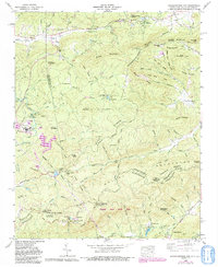
1965 Map of Standingstone Mtn.
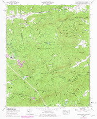
USGS Topo · Published 1991About this map
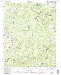
Standingstone Mountain anchors this rugged section of the Blue Ridge, where the borders of Transylvania, Henderson, and Greenville counties converge. The terrain is defined by the Tennessee Valley Divide, which separates the waters flowing toward the Gulf of Mexico from those heading to the Atlantic. Notable landmarks include several youth and religious camps like Camp Blue Star, Sky Valley Pioneer Camp, and Socareda Camp, reflecting the area's mid-century role as a retreat destination.
Find a feature on this map
133 named features on this map. Tap any name to fly to it.
Don’t see what you’re looking for? This feature index may not catch every label — zoom into the map to look around manually.
Map Details
Editions of this 1965 Standingstone Mtn. Map
5 editions found
Other maps of this area

1905 · Pisgah
USGS Topo · 1:125,000

1906 · Pisgah
USGS Topo · 1:125,000

1907 · Saluda
USGS Topo · 1:125,000

1935 · Brevard
USGS Topo · 1:24,000

1935 · Standingstone Mtn.
USGS Topo · 1:24,000

1935 · Horse Shoe
USGS Topo · 1:24,000

1935 · Hendersonville
USGS Topo · 1:24,000

1935 · Table Rock
USGS Topo · 1:24,000

1935 · Zirconia
USGS Topo · 1:24,000

1935 · Pisgah Forest
USGS Topo · 1:24,000
Featured Places
- Jeter Mountain Terrace, NC
- Greenville County, SC
- Henderson County, NC
- Transylvania County, NC
- United States