
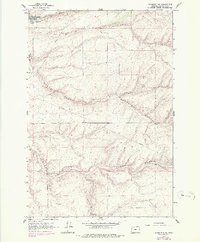
1962 Map of Stanfield SE
USGS Topo · Published 1964About this map
Cold Springs National Wildlife Refuge anchors the northwest corner of this 1962 terrain, where the Cold Springs Reservoir serves as a critical water source in an otherwise arid landscape. This high plateau area in Umatilla County is defined by deep, winding drainages like Despain Gulch and Stage Gulch, which carve through the volcanic soils typical of the region. A network of pipelines, jeep trails, and an unnamed trail suggest an infrastructure focused on resource management and livestock movement rather than dense residential growth. The small settlement of Lenz and a local Gravel Pit appear as the primary markers of human industry, illustrating the rural, agricultural character of the territory just south of the Columbia River basin before modern development.
Find a feature on this map
10 named features on this map. Tap any name to fly to it.
Don’t see what you’re looking for? This feature index may not catch every label — zoom into the map to look around manually.
Map Details
Editions of this 1962 Stanfield SE Map
2 editions found
Other maps of this area

1908 · Umatilla
USGS Topo · 1:125,000

1935 · Pendleton
USGS Topo · 1:125,000

1953 · Pendleton
USGS Topo · 1:250,000

1956 · Pendleton
USGS Topo · 1:250,000

1962 · Hat Rock
USGS Topo · 1:24,000

1962 · Stanfield
USGS Topo · 1:24,000

1962 · Juniper
USGS Topo · 1:24,000
1966 · Juniper Canyon
USGS Topo · 1:24,000

1966 · Holdman
USGS Topo · 1:24,000
1966 · Barnhart
USGS Topo · 1:24,000