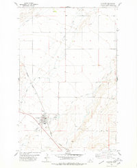
1978 Map of Stanford
USGS Topo · Published 1979About this map
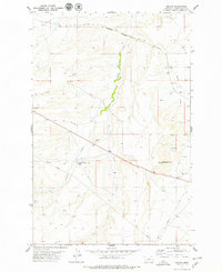
Stanford serves as the central hub of this Central Montana landscape, situated at the intersection of rail and road near the base of the Little Belt Mountains. The town is clearly defined by its municipal features, including the Rodeo Ground, the local Cemetery, and a network of Gravel Pits that suggest a reliance on local mineral resources. The Burlington Northern railroad cuts a diagonal path through the prairie, following the natural drainage of Wolf Creek.
Find a feature on this map
20 named features on this map. Tap any name to fly to it.
Don’t see what you’re looking for? This feature index may not catch every label — zoom into the map to look around manually.
Map Details
Editions of this 1978 Stanford Map
This is the sole edition of this map. No revisions or reprints were ever made.
Other maps of this area

1890 · Fort Benton
USGS Topo · 1:250,000

1892 · Fort Benton
USGS Topo · 1:250,000

1897 · Fort Benton
USGS Topo · 1:250,000

1954 · Great Falls
USGS Topo · 1:250,000

1957 · Great Falls
USGS Topo · 1:250,000
1978 · Stanford NE
USGS Topo · 1:24,000

1978 · Leiberg Coulee
USGS Topo · 1:24,000
1978 · Benchland
USGS Topo · 1:24,000
1978 · Windham
USGS Topo · 1:24,000
1978 · Merino
USGS Topo · 1:24,000
Featured Places
- Stanford, MT
- J and M Trailer Court, MT
- Cotton Trailer Court, Stanford
- Judith Basin County, MT
- United States