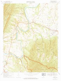
1967 Map of Stanley
USGS Topo · Published 1969About this map
The South Fork Shenandoah River winds through the heart of Page Valley, defining the agricultural and transport corridor of the late 1960s. This survey, under the direction of State Geologist James L. Calver, documents a landscape bounded by Shenandoah National Park and the George Washington National Forest. Rural settlements like Alma, Newport, and Ingham are clustered along the river and the Norfolk and Western rail line. Local social life is evidenced by the numerous country churches and schools, such as St Lukes Ch, Hillard Chapel, and the County High Sch. The topography transitions sharply from the fertile river bottoms to the steep slopes of Dovel Mountain and Dog Slaughter Ridge, where small runs like Stony Run and Honey Run drain toward the river.
Find a feature on this map
55 named features on this map. Tap any name to fly to it.
Don’t see what you’re looking for? This feature index may not catch every label — zoom into the map to look around manually.
Map Details
Editions of this 1967 Stanley Map
2 editions found
Other maps of this area

1892 · Woodstock
USGS Topo · 1:125,000

1892 · Gordonsville
USGS Topo · 1:125,000

1892 · Harrisonburg
USGS Topo · 1:125,000

1893 · Luray
USGS Topo · 1:125,000

1905 · Luray
USGS Topo · 1:125,000

1929 · Stony Man
USGS Topo · 1:48,000

1930 · Madison
USGS Topo · 1:48,000

1933 · Stony Man
USGS Topo · 1:62,500

1933 · Madison
USGS Topo · 1:62,500

1937 · Elkton
USGS Topo · 1:62,500