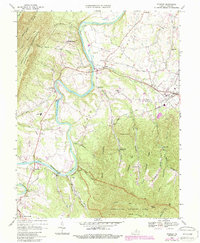
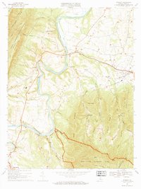
1967 Map of Stanley
USGS Topo · Published 1987About this map
The South Fork Shenandoah River meanders through Page Valley on this 1960s topographic record, updated for the 1980s. This corridor serves as a vital transportation and utility artery, featuring the Norfolk and Western railroad and an extensive pipeline running parallel to the water. The landscape is defined by the sharp contrast between the level valley floor and the wooded heights of Shenandoah National Park and George Washington National Forest. Settlement is concentrated in towns like Stanley and Shenandoah, with smaller rural communities such as Alma and Ingham supporting the agrarian and industrial life of Page County. Notable landmarks include the Powerplant on the riverbank, the County High Sch, and the river access at Grove Hill Landing. Numerous local houses of worship, including St Lukes Ch and St Pauls Ch, anchor the small rural neighborhoods throughout the foothills.
Find a feature on this map
61 named features on this map. Tap any name to fly to it.
Don’t see what you’re looking for? This feature index may not catch every label — zoom into the map to look around manually.
Map Details
Editions of this 1967 Stanley Map
2 editions found
Other maps of this area

1892 · Woodstock
USGS Topo · 1:125,000

1892 · Gordonsville
USGS Topo · 1:125,000

1892 · Harrisonburg
USGS Topo · 1:125,000

1893 · Luray
USGS Topo · 1:125,000

1905 · Luray
USGS Topo · 1:125,000

1929 · Stony Man
USGS Topo · 1:48,000

1930 · Madison
USGS Topo · 1:48,000

1933 · Stony Man
USGS Topo · 1:62,500

1933 · Madison
USGS Topo · 1:62,500

1937 · Elkton
USGS Topo · 1:62,500