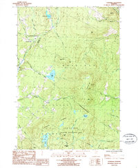
1986 Map of Stannard
USGS Topo · Published 1987About this map
Stannard Mountain dominates the central terrain of this quadrangle, standing as a high point between the Lamoille River valley and the headwaters of numerous brooks. The landscape is defined by the rural settlements of Stannard and East Greensboro, which represent small clusters of development in an area otherwise characterized by timbered slopes and water bodies. The presence of the Steam Mill Brook Wildlife Management Area underscores the region's focus on conservation and natural resource management by the mid-1980s.
Find a feature on this map
47 named features on this map. Tap any name to fly to it.
Don’t see what you’re looking for? This feature index may not catch every label — zoom into the map to look around manually.
Map Details
Editions of this 1986 Stannard Map
This is the sole edition of this map. No revisions or reprints were ever made.
Other maps of this area

1928 · Hardwick
USGS Topo · 1:62,500

1934 · Hardwick
USGS Topo · 1:48,000

1935 · Lyndonville
USGS Topo · 1:48,000

1938 · Hardwick
USGS Topo · 1:62,500

1938 · St. Johnsbury
USGS Topo · 1:48,000

1939 · Lyndonville
USGS Topo · 1:62,500

1939 · Plainfield
USGS Topo · 1:48,000

1940 · Plainfield
USGS Topo · 1:62,500

1943 · Plainfield
USGS Topo · 1:62,500

1943 · St. Johnsbury
USGS Topo · 1:62,500