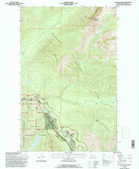
1994 Map of Stanton Lake
USGS Topo · Published 1997About this map
Middle Fork Flathead River serves as the central artery for this mountainous region, defining the complex intersection of federal land boundaries in Northwest Montana. The river corridor facilitates the path of the Burlington Northern railroad, which snakes through the dramatic topography of John F Stevens Canyon and crosses Theodore Roosevelt Pass. This passage represents a vital transportation link between the high peaks of Glacier National Park to the north and the Flathead National Forest to the south.
Find a feature on this map
28 named features on this map. Tap any name to fly to it.
Don’t see what you’re looking for? This feature index may not catch every label — zoom into the map to look around manually.
Map Details
Editions of this 1994 Stanton Lake Map
This is the sole edition of this map. No revisions or reprints were ever made.
Other maps of this area

1904 · Chief Mountain
USGS Topo · 1:125,000

1914 · Nyack
USGS Topo · 1:125,000

1938 · Chief Mountain
USGS Topo · 1:125,000

1960 · Cut Bank
USGS Topo · 1:250,000

1963 · Cut Bank
USGS Topo · 1:250,000

1964 · Cut Bank
USGS Topo · 1:250,000

1964 · Essex
USGS Topo · 1:24,000

1964 · Nyack
USGS Topo · 1:24,000

1964 · Pinnacle
USGS Topo · 1:24,000

1964 · Stanton Lake
USGS Topo · 1:24,000