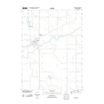
2011 Map of Stanton
USGS Topo · Published 2011About this map
The town of Stanton serves as the central hub of this Nebraska landscape, situated along the winding course of the Elkhorn River. The area’s agrarian character is defined by a dense grid of rural roads and the convergence of several waterways, including Butterfly Creek, Sand Creek, and Maskenthine Creek. For local historians and genealogists, the map identifies several significant interment sites, such as the Independent Order of Odd Fellows Cemetery, Zander Cemetery, and Koch Cemetery. Infrastructure and community gathering points are well-documented, from the Stanton Post Office in the town center to the Stanton County Fairgrounds nearby. Significant water management features are also evident, including the Maskenthine Reservoir, created by the Maskenthine Multiple-Purpose Dam, and the Sand Creek Reservoir 2 located further south, illustrating the region's historical efforts to manage its hydrology for agriculture and flood control.
Find a feature on this map
39 named features on this map. Tap any name to fly to it.
Don’t see what you’re looking for? This feature index may not catch every label — zoom into the map to look around manually.
Map Details
Editions of this 2011 Stanton Map
This is the sole edition of this map. No revisions or reprints were ever made.
Other maps of this area

1955 · Sioux City
USGS Topo · 1:250,000

1955 · Fremont
USGS Topo · 1:250,000

1957 · Fremont
USGS Topo · 1:250,000

1958 · Sioux City
USGS Topo · 1:250,000

1958 · Fremont
USGS Topo · 1:250,000

1959 · Sioux City
USGS Topo · 1:250,000

1963 · Hoskins
USGS Topo · 1:24,000

1963 · Madison SE
USGS Topo · 1:24,000

1963 · Pilger
USGS Topo · 1:24,000

1963 · Wayne SW
USGS Topo · 1:24,000