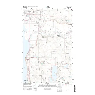
2014 Map of Stanwood
USGS Topo · Published 2014About this map
The Stillaguamish River delta and its surrounding lowlands define this corner of Snohomish County, where the river bifurcates into Hat Slough and other intricate waterways before reaching Port Susan. The land use is dominated by a dense network of named family agricultural operations, including Kwant Dairy, Stalkfleet Farm, and Youngren Farms, reflecting a deeply rooted rural economy. The infrastructure of the BNSF Railway connects established communities like Stanwood and Silvana, while the presence of the Stillaguamish Grange and Green Wood Grange highlights the area's social history. To the south, the landscape shifts toward the recreational and residential clusters around Lake Goodwin and Lake Shoecraft, as well as the coastal sites at Warm Beach and Kayak Point. Notable local landmarks like Pleasant View Cem and Camp Killoqua provide specific points of interest for genealogical and local history research.
Find a feature on this map
111 named features on this map. Tap any name to fly to it.
Don’t see what you’re looking for? This feature index may not catch every label — zoom into the map to look around manually.
Map Details
Editions of this 2014 Stanwood Map
This is the sole edition of this map. No revisions or reprints were ever made.
Other maps of this area

1911 · Mount Vernon
USGS Topo · 1:125,000

1940 · Mt Vernon
USGS Topo · 1:62,500

1941 · Marysville
USGS Topo · 1:62,500

1943 · Marysville
USGS Topo · 1:62,500

1943 · Mt Vernon
USGS Topo · 1:62,500

1943 · Stanwood
USGS Topo · 1:62,500

1944 · Clear Lake
USGS Topo · 1:62,500

1956 · Tulalip
USGS Topo · 1:24,000

1956 · Arlington West
USGS Topo · 1:24,000
1956 · Stanwood
USGS Topo · 1:24,000