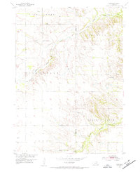
1954 Map of Star
USGS Topo · Published 1956About this map
The small settlement of Star sits in the northern reaches of this mid-century landscape, where the agricultural plateaus of Steel Creek township meet the deeply dissected drainages of the Verdigre Creek system. The map records a rural infrastructure defined by township-line schools and family burial grounds, such as School No 45 and the Grimton Cem located in the southeastern Walnut Grove district. The topography is dominated by the intricate carving of the North Branch Verdigre Creek and Lamb Creek, which create a complex network of ridges and draws across the Holt and Knox County line. This 1954 field check captures the area's development as part of the Missouri River Basin program, showing a landscape of scattered farmsteads served by landmarks like Cedar Corner Sch and Grimton Sch, connected by a network of unimproved dirt roads and light-duty paths.
Find a feature on this map
17 named features on this map. Tap any name to fly to it.
Don’t see what you’re looking for? This feature index may not catch every label — zoom into the map to look around manually.
Map Details
Editions of this 1954 Star Map
2 editions found
Other maps of this area

1950 · Dorsey NW
USGS Topo · 1:24,000

1950 · Pishelville
USGS Topo · 1:24,000

1952 · Dorsey
USGS Topo · 1:24,000

1954 · Walnut
USGS Topo · 1:24,000

1954 · Dorsey SW
USGS Topo · 1:24,000

1954 · Star
USGS Topo · 1:24,000

1955 · O'Neill
USGS Topo · 1:250,000

1958 · Page
USGS Topo · 1:24,000

1959 · O'Neill
USGS Topo · 1:250,000

1963 · Venus
USGS Topo · 1:24,000